Setting notes for "Rainshadow Road"
May. 25th, 2021 10:12 pmThese are the setting notes for "Rainshadow Road."
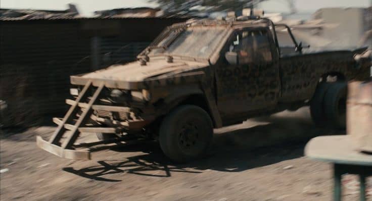
While road warriors are often thought of as a movie trope, maurading militias occur in real life. With a diminished population especially short on combat-capable adults, the Aftermath has very little of the road raiders common in most post-apocalyptic settings. However, all societies have some people who would rather steal what someone else has than do their own work. A few bands of tobeys prowl the highways in wartrucks designed to disable or destroy other vehicles. This one is a semi engine with front blades. Here is a pickup with front wedge, and one with a machine gun in back.
A caterpillar is a modular vehicle that usually has a short, stubby body on tank treads. Occasionally longer ones appear. Mounting points on the front and back allow the attachment of snowplows, brush guards, cargo wagons, other caterpillar modules, etc. They can travel over snow, mud, sand, and other off-road terrain. However, they cannot navigate deep ditches or dense forest. This approach becomes much more popular over time as roads continue to degrade and tires become difficult if not impossible to source.
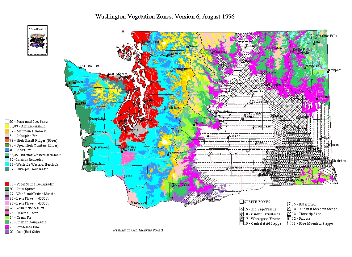
Drylands include sub-humid, semi-arid, and arid zones. (Some definitions may also include hyper-arid and/or cold dry zones.) This includes a variety of deserts, grasslands, scrublands, mountains, and other habitat types. The Columbia River Basin in the rainshadow of the Cascade Mountains in the eastern part of former Washington includes a variety of vegetation types from drier to slightly wetter ones. The Columbia Basin is an arid sagebrush steppe and grassland, surrounded on all sides by areas of higher moisture, predominantly forested, mountainous ecological regions. Habitats within the Blue Mountains ecoregion include desert-like shrubland, grasslands, pine forests and alpine highlands. Little rain falls in the shadow, making Walla (formerly Eastern Washington) much drier than Limpia (formerly Western Washington).
This map shows the roads and cities of former Washington. Rainshadow Road is the part of former Interstate 90 from the eastern border through the Columbia Basin (the rainshadow) to the Cascade Mountains. Southshadow Road is former Interstate 82 from the southern border to where it joins Rainshadow Road (former I-90). Little Shadow Road is former Highway 395 between Rainshadow Road (former I-90) and Southshadow Road (former (-82). By 15 A.E. Little Shadow Road is starting to decline and parts of it are increasingly difficult to get through.
Femdale is an all-female commune outside the ruins of former Ferndale, allied with the nearby Lummi Nation. Saddle Hills is a commune some distance from the ruins of former Seattle, now raising Rocky Mountain Horses. Lazarus Lake is a commune outside the ruins of former Moses Lake, so named because for some unknown reason Grunge victims who washed in its water had a higher survival rate. Now it has a reputation for healing water. Sunnyside Down is a commune outside the ruins of the former Sunnyside on Southshadow Road (former (I-82). Poorland is a commune outside the ruins of the former Tri-Cities (Richland-Kennewick-Pasco) on Southshadow Road (former (I-82). Due to the former Department of Energy Pacfic Northwest National Laboratory, Poorland has a stock of green energy equipment. The small town of Mesa has survived but now calls itself End Table. It has taken in some survivors from other places and is making a concerted effort to keep Little Shadow Road open. Another small town, Lind, has shrunk in population and is struggling to survive. They are the two largest surviving settlements on that road, Connell having fallen apart before the End due to wildfires. Wallaby is a commune outside the ruins of former Walla Walla. Spokes is a commune outside the ruins of former Spokane. It is known for its supply of vehicles and parts, particularly bicycles and automotive wheels or tires.
Here is a description and a map of the ecological zones in former Washington. Femdale (near former Ferndale) and Lummi Nation have Puget Sound Douglas Fir. So does Saddle Hills (some distance from former Seattle). Lazarus Lake (near former Moses Lake) is in the Central Arid Steppe. So are Sunnyside Down (near former Sunnyside) and Poorland (outside former Tri-Cities of Richland-Kennewick-Pasco). This dry, sandy area supports needle and thread grass, Indian ricegrass, or Sandberg’s bluegrass in combination with sagebrush, hopsage, or winterfat shrubs more sparsely than areas dominated by sagebrush or grasses. End Table (former Mesa) is on the border between Central Arid Steppe and Wheatgrass/Fescue. Lind has Big Sage/Fescue. Spokes has Ponderosa Pine.
This map shows the military installations of former Washington, including the Fairchild Air Force Base.
Airway Heights was a town in Spokane County, Washington, somewhat west of Spokane. Its population was 6,114 in 2010 . The name came from its proximity to the runways at Fairchild Air Force Base and Spokane International Airport.
Ferndale was a city in Whatcom County, Washington. Its population was 11,415 in 2010. The third largest city in Whatcom County, it was near the Lummi Nation.
The Lummi tribe belongs to the Coast Salish ethnolinguistic group in the Pacific Northwest region of Washington state. Many of them live on or near the Lummi Indian Reservation west of Bellingham in western Whatcom County, a little south of the Canadian border.
Gaited horses become much more valuable as transport After. In this setting, the Western Mountain Horse is a breed within the family of Mountain Horses developed by crossing Rocky Mountain Horses (which actually came from Kentucky) with wild mustangs to produce a small, hardy horse that can thrive on poor fodder while performing smooth gaits.
Prior to the End, the Sovereign Military Order of Malta had sent humanitarian aid to the state of Washington, based in Moses Lake. In the Aftermath, they established two related entities: an armey called the Knights Hospitaller and the House of St. John in the commune of Lazarus Lake. The Knights Hospitaller roam the surrounding area providing protection and first aid. The House of St. John is a combination monastery-hospital-inn.
Sacred hospitality is making a much stronger return in the new cultures. Within a few years After, gathering spots begin to emerge from the ruins of civilization. Some places are reinventing the monastary-hospital-inn. Clergy in cities were hit because they kept trying to help people, but on average they tend to be lower on sex hormones and higher on age, not as many in the target range. Those outside in monasteries, missionary work, etc. fared much better. I've already spotted one nun running a commune, and it doesn't seem rare: "Mother" and "Father" as titles for elders are popular, and that's likely where it came from.
Moses Lake was a city in Grant County, Washington. Its population was 20,366 in 2010. It was the biggest city in Grant County. It anchored the Moses Lake Micropolitan area, including all of Grant County.
Lind is a small town in Adams County, Washington. Its population was 564 in 2010 and it has been slowly shrinking for some time. However, Lind boasts the largest solar array in the state.
Connell was a town in Franklin County, Washington. Its population was 4,209 in 2010. In this setting, it was overwhelmed by wildfires even before the End. Wildfires are a serious concern in the Columbia Basin. Climate change is making them worse and making fire season longer.
End Table (formerly Mesa) is a small town in Franklin County, Washington. The population was 489 in 2010.
Sunnyside was a city in Yakima County, Washington. Its population was 15,858 in 2010.
The Tri-Cities consisted of three closely linked cities (Kennewick, Pasco, and Richland) at the juncture of the Yakima, Snake, and Columbia Rivers in the Columbia Basin of Eastern Washington. The combined population was 193,567 in 2010 and the 2016 estimate was over 300,000 for the urban area. After the End, refugees formed the commune of Poorland nearby.
Pacific Northwest National Laboratory (PNNL) belonged to the United States Department of Energy, managed by the Department of Energy's (DOE) Office of Science. Its main campus was in Richland, Washington.
Walla Walla was the largest city and county seat of Walla Walla County, Washington. Its population was 31,731 in 2010, and growing rapidly. Combined with its suburbs, there were about 45,000 souls on board.
3. -by
From Old Norse, meaning ‘settlement’ or ‘village’. Since this is at the end and weak, we don’t say /baɪ/, we say /bi/ weakly instead:
The northern stretch of Little Shadow Road has a mix of grasses like fescue and bushes like sagebrush. It supports only a little game, especially during the cold season. The most common include ring-necked pheasants, California quail, mourning doves, and cottontail rabbits. Chukars and gray partridges appear occasionally. Most game clusters around riparian zones or forests, especially the larger animals like deer and pumas.