Notes for "Red Shoes"
Dec. 18th, 2024 11:47 pmHere are the notes for "Red Shoes."
WARNING: Like the poem, some of the notes deal with heinous things and are disturbing.
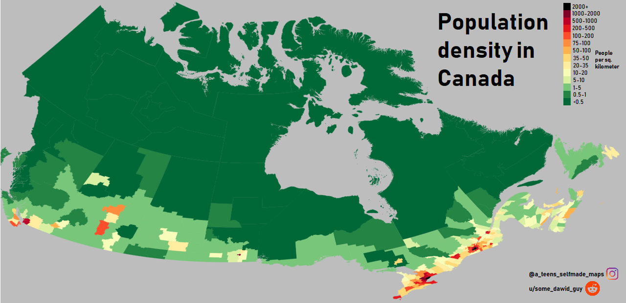
Canada Population Density Map
Most of Canada has less than 0.5 people per square kilometer. The south has higher density, but there are really just four major population centers that hold most of the people. In much of the territory, you can travel for many kilometers without encountering anyone. Canada is a very easy place to hide if you don't want to be found.
Canada Tribes Map
The original tribe was Chipewyan. Subsequently, the Red Knife tribe took in numerous members from Cree, Dene, and Métis peoples with a few Dane-zaa (Beaver), Dene Thaʼ (South Slavey), Caribou Inuit, and others. A quirk of Red Knife is that they distinguish between people of pure native blood and Métis, but they value both equally: the first for maintaining the old traditions and bloodlines, the second for making it easy to mingle with the mainstream. Red Knife purebloods exchange mates with allied and neighboring tribes, which helps keep the gene pool diverse. Red Knife Métis women often go manhunting in the cities, searching out mates with light-colored hair, eyes, and skin. It's common for them to have at least one child each with a pureblooded tribe member and with a white outsider. The main languages are Athabascan / Dene ones including Chipewyan and Dene Thaʼ (South Slavey), the Algonquian one Cree; for outside purposes English and French; a few other indigenous or immigrant languages spoken by particular families or settlements. Red Knife made a point of preserving every possible language precisely to spite the missionaries who wanted to stamp out every language but their own.
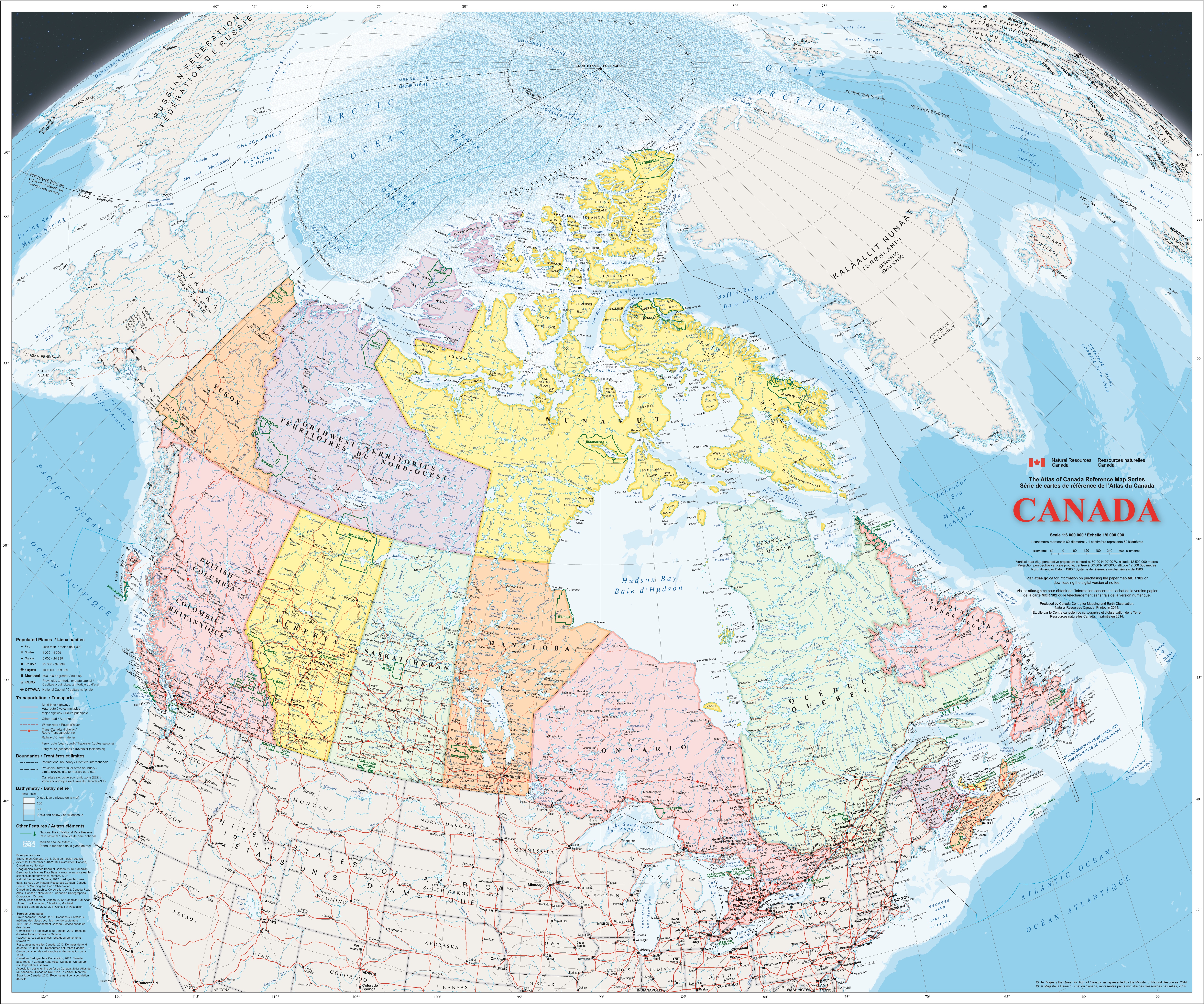
The territory of the Red Knife tribe is roughly triangular, from Lake Athabasca and Reindeer Lake in the west to Hudson Bay in the east. It is south of Dene Tha and Caribou Inuit tribes, east of Beaver, and north of Swampy Cree. The Caribou River forms the northeast boundary with the Caribou Inuit. Red Knife territory lies primarily in Saskatchewan and Manitoba provinces, with just a little in Alberta around the western tip of Lake Athabasca. The largest town is Bearville / L-Churchill, Manitoba. Others include Tadoule Lake, Manitoba; Lac Brochet, Manitoba; Fort du Brochet, Manitoba; Lynne Lake, Manitoba; Wollaston Lake, Saskatchewan; Stony Rapids, Saskatchewan; Fond du Lac, Saskatchewan; Southend Reindeer, Saskatchewan; and Little Athens / Fort Chipewyan, Alberta.
(Pukatawagan, Leaf Rapids, and South Indian Lake are all south of Red Knife territory in Manitoba. La Loche, Patuanak, Pinehouse Lake, Stanley Mission, and Sandy Bay are all south of Red Knife territory in Saskatchewan.) The largest populations of Red Knife people living in the bush are in north-central Saskatchewan followed by some in north-central Manitoba.
Canada Multiple Features Map
Canada Large Detailed Map
In Terramagne-Canada, the town of Bearville (local-Churchill) was settled by Métis members of the Red Knife tribe and their allies, thus remains prevailingly controlled by them. It permits scientists who study polar bears, but does not encourage tourists. Canada is permitted a certain illusion of governmental relevance, but nobody takes it too seriously. People who disagree tend to move away, and those who persist in making a nuisance of themselves fall prey to the many hazards of living in the north.
In Terramagne-Canada, the Wapusk Cree Reserve occupies the area of Wapusk National Park in local-Canada. C Churchill at the top of the map stands for City Churchill, the reserve's hamlet with post offices and other necessities. Most Wapusk Cree who live off-reserve are in the nearby town of Churchill where the river meets the Hudson Bay. They are quiet, neighboring allies of the Red Knife tribe.
In T-Canada, Tadoule Lake is a Red Knife settlement. During the 1960s-70s, they took in some Dene families who wished to return to a traditional life hunting barren-ground caribou, along with a busload of hippies who wished to form an off-grid commune for similar reasons. In modern times, Tadoule Lake is a tiny community with a post office and other essentials for the Caribou Eaters Reserve. Its smuggling operations include contacts with Kraken and Ras el Hanout, thus have not attracted negative attention from Canadian authorities. Instead it is a particularly quiet and ignored area that has come to host a number of sunken bunkers for Kraken (north of town) and for Red Knife people (south of town).
In T-Canada, Lac Brochet is part of Red Knife territory and the North Shore Reserve of people with Dene and Red Knife heritage. This unincorporated community is the administrative centre.
In T-Canada, Fort du Brochet is an unincorporated community providing services to people of Cree and Red Knife heritage, most of whom live in the bush. They continue traditions of hunting, trapping, fishing, and otherwise harvesting lake and forest products for trade.
In T-Canada, Lynne Lake is a town with a lively wilderness industry whose outfitters supply activities such as hiking, camping, sport fishing, and big-game hunting of bear and moose. It was named after Lynne Smith, formerly chief engineer of a mining company. She fell in love with a Red Knife man, convinced the company that the place was no good for mining, and instead promoted it as ideal for wilderness excursions. (She concealed its gold resources, and never looked into the nickel or other ores.) This created employment opportunities for Red Knife people who wished to continue the "Indian guide" tradition.
In T-Canada, Wollaston Lake is an unincorporated community in the Hatchet Lake Reserve for people of Dene and Red Knife heritage.
In T-Canada, Stony Rapids is a northern hamlet and the administrative centre of the Black Lake Reserve for people of Dene, Chipewyan, Woods Cree, and Red Knife heritage. It includes a small hospital.
In T-Canada, Fond du Lac is an unincorporated settlement of Métis people from Dene and Red Knife descent. Most of them live in the bush and prefer a traditional life of fishing, hunting and trapping.
In T-Canada, Southend Reindeer is a community that serves as the administrative centre of the Reindeer Lake Reserve for people of Cree and Red Knife descent along with a few Dene.
In T-Canada, Little Athens / Fort Chipewyan is a hamlet that grew out of a trading post. Residents are mostly Chipewyan, Cree, Red Knife, or Métis. It's an early archive of adventure, folklore, and history featuring one of the more successful if subtle alliances between immigrants and indigenous people. It was here that the people of Red Knife got the idea to learn the languages and customs of outsiders in secret so as to pass among them unnoticed. It remains a small but devoted and powerful anchor of heritage languages, not only for Chipewyan but other Athabascan languages, and to a lesser extent heritage languages from different families.
A solar farm dates back to the 1960s, when a group of hippies approached from the back-to-the-land movement, wanting a way to develop green technologies that could withstand the rigors of the northern interior. Indigenous people living in town were all in favor of energy sovereignty. Thus Little Athens became a favored testing spot for new solar panels and other inventions. Among the more interesting innovations are floating "canoe panels" on Lake Athabasca whose undersides grow algae that attracts more fish.
In T-Canada, the Wood Buffalo Reserve occupies what in L-Canada is Wood Buffalo National Park. It belongs to indigenous people with Dane-zaa (Beaver), Chipewyan Dene Thaʼ (South Slavey), Woods Cree, and Métis heritage. Of these, the Beaver tribe was historically dominant in the area, with Chipewyan and Dene Tha' allies nearby. The Woods Cree arrived as refugees from the east and joined with a treaty. The people of Wood Buffalo Reserve are neighbors and quiet allies of the Red Knife tribe. This is one of the areas where Canada tried to exert more control than it succeeded in achieving, largely because Red Knife taught their neighbors the trick of rewarding allies while discreetly disposing of hostile interlopers. It got to where Canada just couldn't find people willing to risk dying of northern hazards to go out there, so they gave up.
In T-Canada, Red River Colony established a number of Protestant Church and Mission School locations in what is now Manitoba around 1820-1840. The one featured here was located within the area now occupied by the city of Winnipeg. During the 1800s, the Red River Colony executed a plan of genocide against local tribes that included kidnapping all the children they could capture and transporting them to concentration camps described as "schools." All of the young victims suffered various abuses and cultural genocide; many were murdered on purpose or killed through abuse, constituting acts of physical genocide.
The Red River Rebellion of 1869 went rather differently with Métis leader Louis la Rouge / Louis Riel (October 22, 1844 - December 22, 1925) belonging to the Red Knife tribe as a son of Red Knife herself. The Métis people established an effective regional government, ousting companies and competitors. Canada nominally expanded to include what became the province of Manitoba, but did not consider the resources of the area to be losing a lot of people sent there to settle it. In addition to the extreme natural hazards, of course, the Red Knife tribe was quietly killing off those hostile to their survival and interests. In 1884, Louis also assisted Métis leaders in Saskatchewan as they negotiated with the Canadian government, which was still of the opinion that problems which preferred to stay lost in the wilderness were very well welcome to do so instead of coming into town to cause trouble.
In T-Canada, the notorious bad luck of the Red River Colony was ruthlessly assisted by indigenous peoples loathe to give up their independence, using everything from sabotage to medicine powers. Read about the Red River.
Canada has always had difficulty controlling the interior with its formidable wilderness, natural hazards, and thinly spread but fiercely independent population. Currently, local-Canada has just plain given up trying to control wildfires there -- and that's a sign of civilization collapse. Even modern technology struggles to oversee territory that large and thinly inhabited. Now imagine how much harder it would be to take and keep territory earlier. It's an easy place to get lost in.
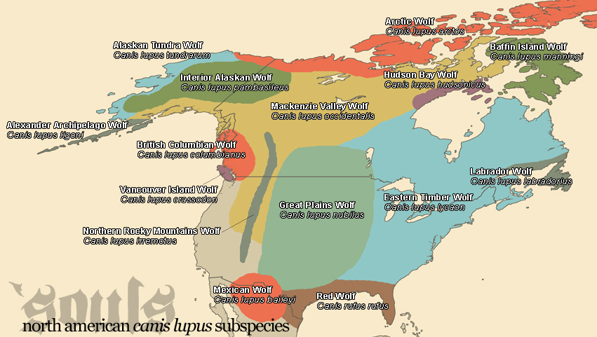
Timber wolves once spanned most of North America with numerous subspecies.
WARNING: Like the poem, some of the notes deal with heinous things and are disturbing.
Canada Population Density Map
Most of Canada has less than 0.5 people per square kilometer. The south has higher density, but there are really just four major population centers that hold most of the people. In much of the territory, you can travel for many kilometers without encountering anyone. Canada is a very easy place to hide if you don't want to be found.
Canada Tribes Map
The original tribe was Chipewyan. Subsequently, the Red Knife tribe took in numerous members from Cree, Dene, and Métis peoples with a few Dane-zaa (Beaver), Dene Thaʼ (South Slavey), Caribou Inuit, and others. A quirk of Red Knife is that they distinguish between people of pure native blood and Métis, but they value both equally: the first for maintaining the old traditions and bloodlines, the second for making it easy to mingle with the mainstream. Red Knife purebloods exchange mates with allied and neighboring tribes, which helps keep the gene pool diverse. Red Knife Métis women often go manhunting in the cities, searching out mates with light-colored hair, eyes, and skin. It's common for them to have at least one child each with a pureblooded tribe member and with a white outsider. The main languages are Athabascan / Dene ones including Chipewyan and Dene Thaʼ (South Slavey), the Algonquian one Cree; for outside purposes English and French; a few other indigenous or immigrant languages spoken by particular families or settlements. Red Knife made a point of preserving every possible language precisely to spite the missionaries who wanted to stamp out every language but their own.
The territory of the Red Knife tribe is roughly triangular, from Lake Athabasca and Reindeer Lake in the west to Hudson Bay in the east. It is south of Dene Tha and Caribou Inuit tribes, east of Beaver, and north of Swampy Cree. The Caribou River forms the northeast boundary with the Caribou Inuit. Red Knife territory lies primarily in Saskatchewan and Manitoba provinces, with just a little in Alberta around the western tip of Lake Athabasca. The largest town is Bearville / L-Churchill, Manitoba. Others include Tadoule Lake, Manitoba; Lac Brochet, Manitoba; Fort du Brochet, Manitoba; Lynne Lake, Manitoba; Wollaston Lake, Saskatchewan; Stony Rapids, Saskatchewan; Fond du Lac, Saskatchewan; Southend Reindeer, Saskatchewan; and Little Athens / Fort Chipewyan, Alberta.
(Pukatawagan, Leaf Rapids, and South Indian Lake are all south of Red Knife territory in Manitoba. La Loche, Patuanak, Pinehouse Lake, Stanley Mission, and Sandy Bay are all south of Red Knife territory in Saskatchewan.) The largest populations of Red Knife people living in the bush are in north-central Saskatchewan followed by some in north-central Manitoba.
Canada Multiple Features Map
Canada Large Detailed Map
In Terramagne-Canada, the town of Bearville (local-Churchill) was settled by Métis members of the Red Knife tribe and their allies, thus remains prevailingly controlled by them. It permits scientists who study polar bears, but does not encourage tourists. Canada is permitted a certain illusion of governmental relevance, but nobody takes it too seriously. People who disagree tend to move away, and those who persist in making a nuisance of themselves fall prey to the many hazards of living in the north.
In Terramagne-Canada, the Wapusk Cree Reserve occupies the area of Wapusk National Park in local-Canada. C Churchill at the top of the map stands for City Churchill, the reserve's hamlet with post offices and other necessities. Most Wapusk Cree who live off-reserve are in the nearby town of Churchill where the river meets the Hudson Bay. They are quiet, neighboring allies of the Red Knife tribe.
In T-Canada, Tadoule Lake is a Red Knife settlement. During the 1960s-70s, they took in some Dene families who wished to return to a traditional life hunting barren-ground caribou, along with a busload of hippies who wished to form an off-grid commune for similar reasons. In modern times, Tadoule Lake is a tiny community with a post office and other essentials for the Caribou Eaters Reserve. Its smuggling operations include contacts with Kraken and Ras el Hanout, thus have not attracted negative attention from Canadian authorities. Instead it is a particularly quiet and ignored area that has come to host a number of sunken bunkers for Kraken (north of town) and for Red Knife people (south of town).
In T-Canada, Lac Brochet is part of Red Knife territory and the North Shore Reserve of people with Dene and Red Knife heritage. This unincorporated community is the administrative centre.
In T-Canada, Fort du Brochet is an unincorporated community providing services to people of Cree and Red Knife heritage, most of whom live in the bush. They continue traditions of hunting, trapping, fishing, and otherwise harvesting lake and forest products for trade.
In T-Canada, Lynne Lake is a town with a lively wilderness industry whose outfitters supply activities such as hiking, camping, sport fishing, and big-game hunting of bear and moose. It was named after Lynne Smith, formerly chief engineer of a mining company. She fell in love with a Red Knife man, convinced the company that the place was no good for mining, and instead promoted it as ideal for wilderness excursions. (She concealed its gold resources, and never looked into the nickel or other ores.) This created employment opportunities for Red Knife people who wished to continue the "Indian guide" tradition.
In T-Canada, Wollaston Lake is an unincorporated community in the Hatchet Lake Reserve for people of Dene and Red Knife heritage.
In T-Canada, Stony Rapids is a northern hamlet and the administrative centre of the Black Lake Reserve for people of Dene, Chipewyan, Woods Cree, and Red Knife heritage. It includes a small hospital.
In T-Canada, Fond du Lac is an unincorporated settlement of Métis people from Dene and Red Knife descent. Most of them live in the bush and prefer a traditional life of fishing, hunting and trapping.
In T-Canada, Southend Reindeer is a community that serves as the administrative centre of the Reindeer Lake Reserve for people of Cree and Red Knife descent along with a few Dene.
In T-Canada, Little Athens / Fort Chipewyan is a hamlet that grew out of a trading post. Residents are mostly Chipewyan, Cree, Red Knife, or Métis. It's an early archive of adventure, folklore, and history featuring one of the more successful if subtle alliances between immigrants and indigenous people. It was here that the people of Red Knife got the idea to learn the languages and customs of outsiders in secret so as to pass among them unnoticed. It remains a small but devoted and powerful anchor of heritage languages, not only for Chipewyan but other Athabascan languages, and to a lesser extent heritage languages from different families.
A solar farm dates back to the 1960s, when a group of hippies approached from the back-to-the-land movement, wanting a way to develop green technologies that could withstand the rigors of the northern interior. Indigenous people living in town were all in favor of energy sovereignty. Thus Little Athens became a favored testing spot for new solar panels and other inventions. Among the more interesting innovations are floating "canoe panels" on Lake Athabasca whose undersides grow algae that attracts more fish.
In T-Canada, the Wood Buffalo Reserve occupies what in L-Canada is Wood Buffalo National Park. It belongs to indigenous people with Dane-zaa (Beaver), Chipewyan Dene Thaʼ (South Slavey), Woods Cree, and Métis heritage. Of these, the Beaver tribe was historically dominant in the area, with Chipewyan and Dene Tha' allies nearby. The Woods Cree arrived as refugees from the east and joined with a treaty. The people of Wood Buffalo Reserve are neighbors and quiet allies of the Red Knife tribe. This is one of the areas where Canada tried to exert more control than it succeeded in achieving, largely because Red Knife taught their neighbors the trick of rewarding allies while discreetly disposing of hostile interlopers. It got to where Canada just couldn't find people willing to risk dying of northern hazards to go out there, so they gave up.
In T-Canada, Red River Colony established a number of Protestant Church and Mission School locations in what is now Manitoba around 1820-1840. The one featured here was located within the area now occupied by the city of Winnipeg. During the 1800s, the Red River Colony executed a plan of genocide against local tribes that included kidnapping all the children they could capture and transporting them to concentration camps described as "schools." All of the young victims suffered various abuses and cultural genocide; many were murdered on purpose or killed through abuse, constituting acts of physical genocide.
The Red River Rebellion of 1869 went rather differently with Métis leader Louis la Rouge / Louis Riel (October 22, 1844 - December 22, 1925) belonging to the Red Knife tribe as a son of Red Knife herself. The Métis people established an effective regional government, ousting companies and competitors. Canada nominally expanded to include what became the province of Manitoba, but did not consider the resources of the area to be losing a lot of people sent there to settle it. In addition to the extreme natural hazards, of course, the Red Knife tribe was quietly killing off those hostile to their survival and interests. In 1884, Louis also assisted Métis leaders in Saskatchewan as they negotiated with the Canadian government, which was still of the opinion that problems which preferred to stay lost in the wilderness were very well welcome to do so instead of coming into town to cause trouble.
In T-Canada, the notorious bad luck of the Red River Colony was ruthlessly assisted by indigenous peoples loathe to give up their independence, using everything from sabotage to medicine powers. Read about the Red River.
Canada has always had difficulty controlling the interior with its formidable wilderness, natural hazards, and thinly spread but fiercely independent population. Currently, local-Canada has just plain given up trying to control wildfires there -- and that's a sign of civilization collapse. Even modern technology struggles to oversee territory that large and thinly inhabited. Now imagine how much harder it would be to take and keep territory earlier. It's an easy place to get lost in.
Timber wolves once spanned most of North America with numerous subspecies.