Here are the location notes for "The Evolution of Society as a Whole."
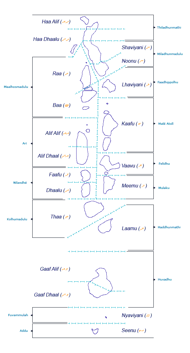
Monday, June 1, 2015 -- The Republic of the Maldives cedes territory from parts of the Laamu, Gaaf Alif, and Gaaf Daal administrative regions to create the nation of Thalassia for Kraken.
Local-Earth provides little detail about the exact national boundaries for the Republic of the Maldives. However, it is generally shown as a large rectangle enclosing the atolls, the shallow water around them, and some deep water between and to the sides of the atolls. For the purposes of T-Maldivian borders, the administrative map provides an approximation, although there is more space to the north and south than shown. After President Latheef grants diplomatic recognition to Kraken, he also gives them a rectangle of ocean territory for their own which spans parts of the Laamu, Gaaf Alif, and Ghaaf Daal administrative regions, appearing in the blank area of the map to the left of those atolls. As the Maldives is a highly active member of the United Nations, its recognition of Kraken causes quite a stir.
Read about the diplomatic recognition of unrecognized states. The Republic of the Maldives belongs to the United Nations but doesn't have much status. Yet.
Achieving Recognition as a State
Step 1: Make sure you are eligible
You must have a defined territory. You must have a permanent population. You must have a government. Your government must be capable of interacting with other states.
Step 2: Declare independence
Step 3: Get recognized
It is at the discretion of existing states whether they recognize, so there is no right to recognition.
Step 4: Join the club
Since its founding in 1945, membership in the United Nations has become the gold standard of international legitimacy. When you are admitted to the U.N, thats a form of approval, Talmon says. Its like a stamp [that says] you are now a full member of the international community.
Applying for U.N. membership is a breeze. According to U.N. rules, all you need to do is write a letter to the secretary-general requesting membership.
Now comes the hard part. The Security Council must refer you to the General Assembly, which must determine by a two-thirds majority that you are a peace-loving state that can carry out the duties of the U.N. Charter.
Its probably not even worth trying this unless youve completed step 3. A number of unrecognized states have applied for U.N. recognition over the years, including American-Indian tribes, but without the credibility bestowed by bilateral recognition, these applications are usually just filed away.
Monday, June 1, 2015 -- The Republic of the Maldives cedes territory from parts of the Laamu, Gaaf Alif, and Gaaf Daal administrative regions to create the nation of Thalassia for Kraken.
Thalassia may refer to:
• Thalassia, Greece, a village in northern Greece
• Thalassia (plant), a genus of seagrass commonly known as "turtle grass"
• Thalassia (queen), a queen of Characene
θᾰ́λᾰσσᾰ • (thálassa) f (genitive θᾰλᾰ́σσης); first declension
1. sea
2. the Mediterranean Sea
3. channel
4. salt water
Sierpinski City is named after the Sierpinski Snowflake. This fractal creates the geometric structure of the floating city. In 2016, construction is well underway, though not complete -- but a fractal, modular city can grow as much as desired anyhow. Thalassia has a variety of other habitats in progress that use different styles.
Sierpinkski Hexagon / Snowflake
Like the pentaflake, there is also a variation of the hexaflake, called the Sierpinski hexagon, that has no central hexagon.[5] Its Hausdorff dimension equals ≈ 1.6309. This variation still contains infinitely many Koch curves of 60 degrees.
Sierpinski City can grow in a fractal expansion.
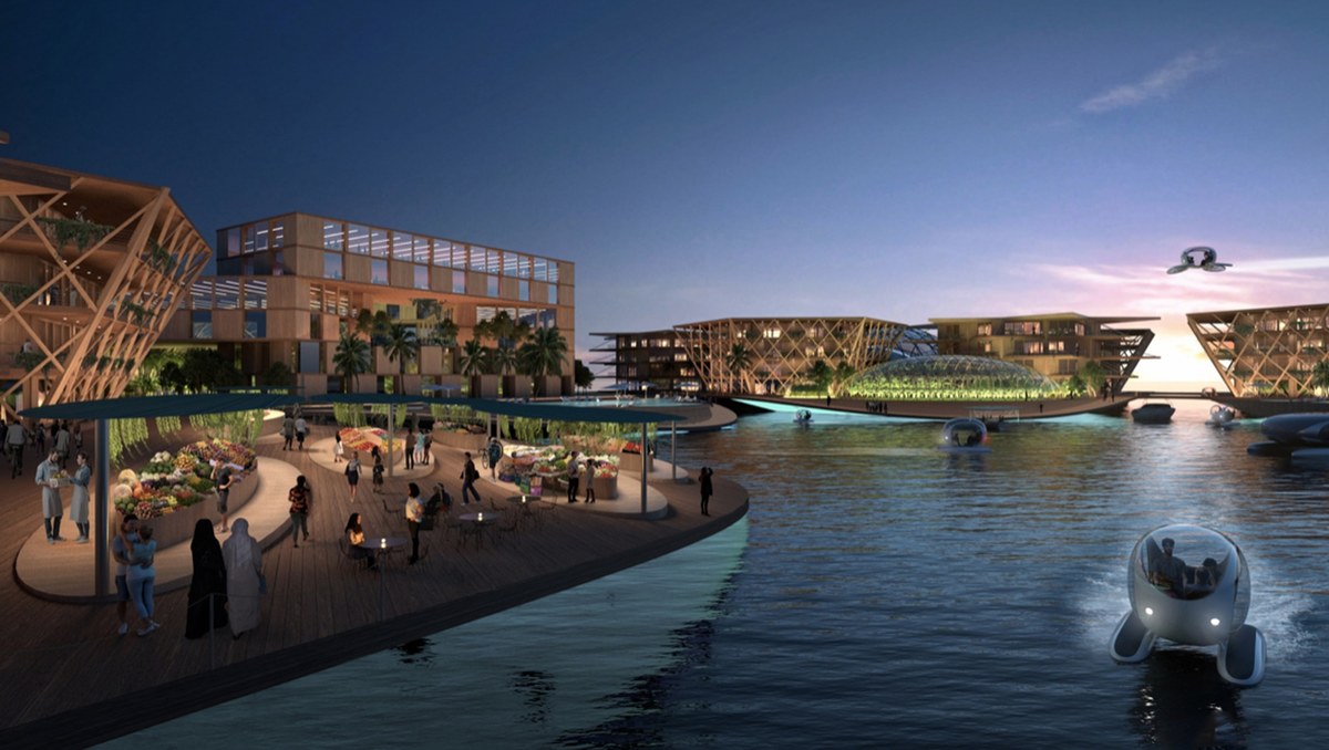
A neighborhood is a floating triangle of 2 hectares. A basic design calls for housing 300 people in 6 hexagonal buildings, although multiple variations exist. Typically most of the surface is deck with some gardens. Each neighborhood triangle provides production, protection, and connection at the points. The center and one point have large domed gardens. Another point has swimming pools or other activity space. One point is a dock for water travel. Each neighborhood triangle offers about 10,000-15,000 square meters of mixed-use space. The hexagons tend to be multipurpose buildings. Typically the ground floor contains a specialty use such as retail, coworking, research labs, restaurants, or makerspace.
A village consists of 6 triangular neighborhoods forming a hexagon of 12.2 hectares. It houses 1,650 people. The triangular neighborhoods are linked with flexible bridges high enough to permit water travel underneath. Here you can see several common building shapes used on the triangles: 6 hexagons, X, Y, 3 oblongs forming an open triangle, and 2 brackets. There are also different uses of the open spaces.
Each village has a unique element on its inward neighborhood triangle. Clockwise from the upper right they are: Spiritual Center, Health Center, Learning Center, Cultural, Athletic Hub, Agora. The Spiritual Center looks like a cluster of bubbles and serves the most common world religions. The big dome in the center is an interfaith house of worship. The six medium domes around it each serve a different tradition: a Christian church, an Islamic mosque, a Hindu temple, a Buddhist temple, a Jewish synagogue, and a folk temple. The small domes between the medium ones include the foyer, bathrooms, and quiet rooms. Additionally, there are several different groves and other sanctuaries for various Pagan faiths scattered around, the Secular Personists have a contemplation room in the C-shaped science building near the Health Center, and the Pastafarians have a kitchen and cafeteria in the triangular building adjacent to the Athletic Hub. The administrative/government building is the Y-shaped one adjacent to the Cultural Center, and its Roundtable is in the cental hub.
There are six standard configurations of buildings in a neighborhood: a C shape, an X shape, a Y shape, 3 bars forming an open triangle, 2 angle brackets, or 6 hexagons. Each of the unique elements has its own shape. The Spiritual Center is a cluster of bubbles. The Health Center is a 6-armed star like a paramedic cross, the Learning Center is a rounded stack of overlapping blocks, the Cultural Center is an assembly of larger and smaller cubes, the Athletic Hub is a concave 6-armed star, and the Agora has two offset triangles stacked on each other.
A city consists of 6 hexagonal villages forming a larger hexagon of 75 hectares. It houses 10,000 people. Smaller triangles of various sizes around the city provide space for farming and other activities. This panel shows a few more building shapes including a 6-pointed star and a C shape.
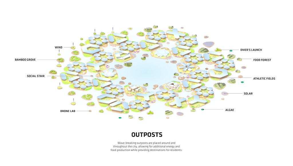
Outposts are floating modules of various sizes, usually triangular. These spread around the city to provide extra space for farming, energy production, recreation, and other purposes.
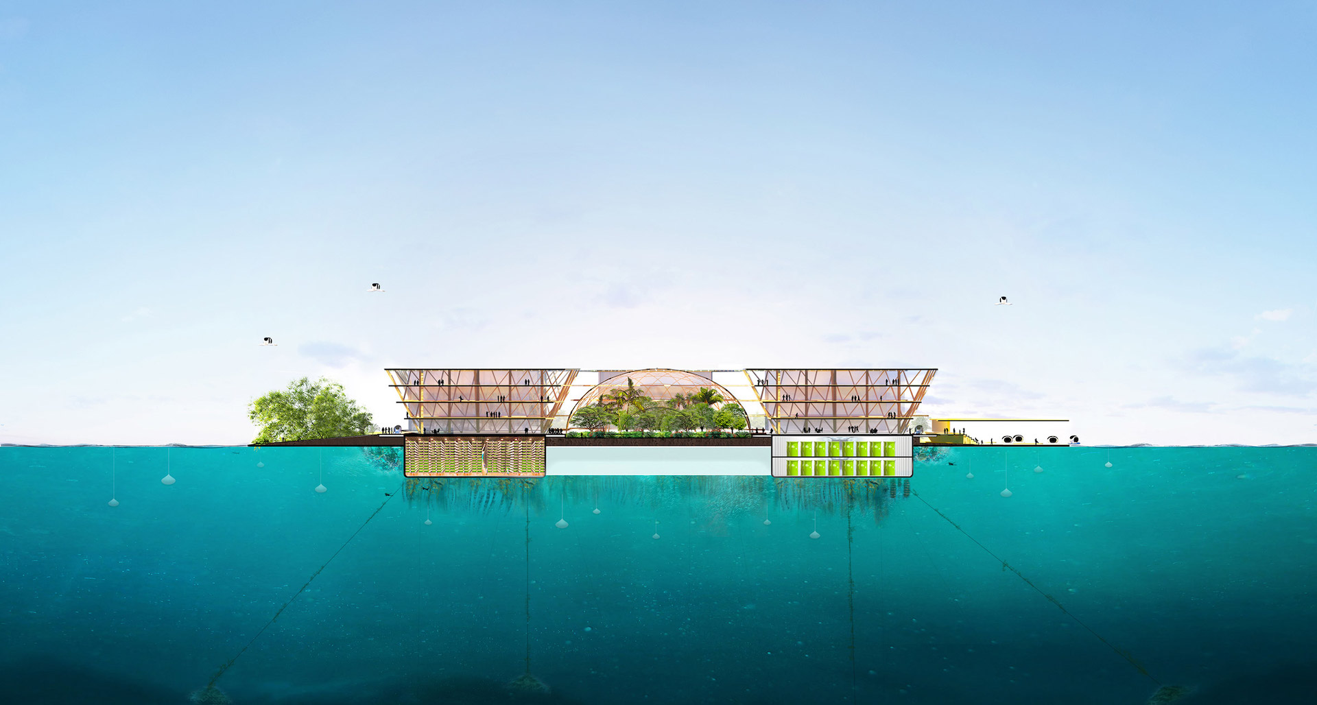
A side view shows the flotation substrate, buildings, central dome, and different points. Biorock reefs provide aquatic habitat and dissipate waves. Low-rise (4-7 stories) buildings have a low center of gravity for stability and wind resistance. This view shows more of the shapes. Different building designs provide diversity of indoor-outdoor spaces, and they come with solar panels for green energy. The center space usually holds a food forest or garden.
Sierpinsky City has a net-zero energy balance. It uses primarily green energy. Solar, wind, and water power provide 30 kwh per person per day.
Sierpinsky City practices fresh water autonomy through the collection of rainwater and recycling of graywater. The system provides 600 liters of fresh water per person per day. No waste gets released into the ocean.
Multiple types of food production supply a minimum 1,880 grams per person per day, with more accounting for high-burn metabolisms. Methods include greenhouses, gardens, aeroponics, aquaponics, and ocean farming. While the output is primarily seafood and produce, the city also raises small livestock such as rabbits and chickens.
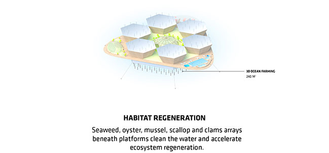
Habitat regeneration involves farming seaweed, bivalves, and other species beneath or around the floating platforms. This cleans the water, attracts fish, provides food, and improves the overall environment.
Locally sourced materials reduce the cost and carbon footprint of shipping. Bamboo can be grown in the city itself. Plastic is purchased from the Maldives just across the border, whose new nanotech processor is chewing through a garbage island and producing high-quality recycled polymer slabs.
A zero-waste system closes the loop with compost and recycling. Usable items are exchanged rather than discarded, and repaired if necessary. The system accounts for 800 grams of cycling waste per person per day.
Residents share community through public space and intentional neighborhood. Terraces on the buildings encourage indoor-outdoor living and socializing.
Mobility is a key feature in Sierpinski City. The hexagonal infrastructure provides efficient travel over boardwalks and over water. Residents can choose from many different modes of travel. Personal power includes walking, biking, and swimming. Watercraft include kayaks, sailboats, and ferries. There are electric cars and delivery vans for some purposes, but no conventional gas vehicles on the boardwalks. Most travel relies on personal power. Shared mobility reduces space demand. Most vehicles are public rather than private.
Much of the city is boardwalk or other smooth paths. Most or all triangles have a harbor for transit. Among the common vehicles are putters, typically meant to hold 1-4 people or cargo. The floor has latching tracks like a van, so a wheelchair can drive in, lock in place, boat to another triangle, and get off. Like the Maldives, Thalassia also uses pedicabs, so less-mobile people can easily catch a ride in most places.
The Loop inside each village is 600 meters, typically traveled by walking. At an average speed of 5 kmh, it takes 5 minutes to complete the Loop. The Civic Loop around the central harbor of the city is 3 km, typically traveled by biking. At an average speed of 10 kmh, it takes 10 minutes to complete the Civic Loop. This makes Sierpinski City a masterpiece of walkable, bikeable, person-scaled infrastructure.
Water mobility connects the whole city. The Water Loop around the outside edge is 4.5 km, usually traveled by boat. At an average speed of 10 knots, it takes 7.5 minutes to complete the Water Loop.
The key principles of Sierpinski City include economical modular construction, net-zero energy, fresh water autonomy, zero waste systems, primarily plant-based diet, habitat regeneration, locally sourced recyclable materials, diverse programs, shared mobility, and a sharing culture.
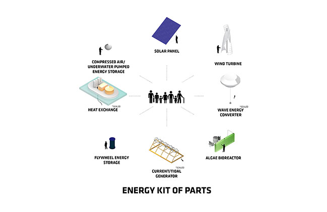
The energy kit of parts includes solar panels, wind turbines, wave energy converters, algae bioreactors, current/tidal generators, flywheel energy storage, heat exchange, and compressed air energy storage.
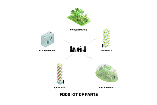
The food kit of parts includes outdoor farming, aeroponics, indoor farming, aquaponics, and ocean farming.
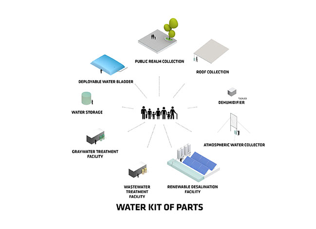
The water kit of parts includes public realm collection, roof collection, dehumidifiers, atmospheric water collectors, renewable desalination facilities, wastewater and graywater treatment facilities, water storage, and deployable water bladders.
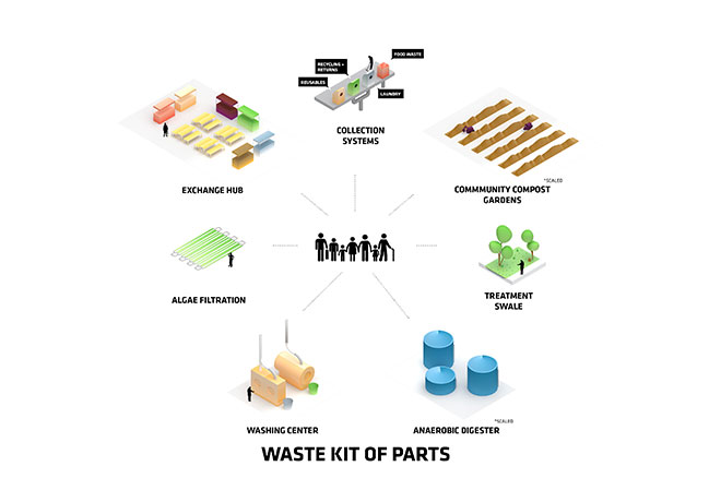
The waste kit of parts includes collection systems, community compost gardens, treatment swales, anaerobic digesters, washing centers, algae filtration, and exchange hubs.
This diagram shows the city's resources of water, food, energy, materials, and waste. They interact in complex patterns to close as many loops as possible.
Overviews show Sierpinski City from above. The approach by boat observes many different types of watercraft as well as parasails overhead.
A side view of a neighborhood harbor shows a market, a garden, and multiple buildings. The central harbor includes various types of watercraft including catamarans and rowboats. Hoverpods can fly or float over water. They come in car to bus sizes.
Sierpinsky City is multiethnic. Some neighborhoods cluster a given group together, while others mix people from many places. This farm scene shows Asian, European, and a few African folks. This market scene has mostly Africans. Here you can see many types of people, including Muslim women, in a different market scene. The village harbor has kayaks on the water, hoverpods and parasails overhead. The same location at dusk shows the night lighting as it comes on. This sidewalk scene has mostly Muslims.
The farm dome holds a food forest of tropical fruit.
The administrative/government building is the Y-shaped one adjacent to the Cultural Center, and its Roundtable is in the cental hub.
The underside of Sierpinski City is buoyant reef rock that can grow seaweed. Coral gardens float nearby.
This outpost farm has submerged rafts for cultivation of Caulerpa racemosa var. turbinata. Fig. 1 Habit of Caulerpa "sea grapes" in cultivation. a Initial growth (1 week) of fronds emerging through the top of the tray, Caulerpa lentillifera monoculture. b Close up of fronds of C. lentillifera. Farming sea vegetables contributes toward food sovereignty.
Monday, June 1, 2015 -- The Republic of the Maldives cedes territory from parts of the Laamu, Gaaf Alif, and Gaaf Daal administrative regions to create the nation of Thalassia for Kraken.
Local-Earth provides little detail about the exact national boundaries for the Republic of the Maldives. However, it is generally shown as a large rectangle enclosing the atolls, the shallow water around them, and some deep water between and to the sides of the atolls. For the purposes of T-Maldivian borders, the administrative map provides an approximation, although there is more space to the north and south than shown. After President Latheef grants diplomatic recognition to Kraken, he also gives them a rectangle of ocean territory for their own which spans parts of the Laamu, Gaaf Alif, and Ghaaf Daal administrative regions, appearing in the blank area of the map to the left of those atolls. As the Maldives is a highly active member of the United Nations, its recognition of Kraken causes quite a stir.
Read about the diplomatic recognition of unrecognized states. The Republic of the Maldives belongs to the United Nations but doesn't have much status. Yet.
Achieving Recognition as a State
Step 1: Make sure you are eligible
You must have a defined territory. You must have a permanent population. You must have a government. Your government must be capable of interacting with other states.
Step 2: Declare independence
Step 3: Get recognized
It is at the discretion of existing states whether they recognize, so there is no right to recognition.
Step 4: Join the club
Since its founding in 1945, membership in the United Nations has become the gold standard of international legitimacy. When you are admitted to the U.N, thats a form of approval, Talmon says. Its like a stamp [that says] you are now a full member of the international community.
Applying for U.N. membership is a breeze. According to U.N. rules, all you need to do is write a letter to the secretary-general requesting membership.
Now comes the hard part. The Security Council must refer you to the General Assembly, which must determine by a two-thirds majority that you are a peace-loving state that can carry out the duties of the U.N. Charter.
Its probably not even worth trying this unless youve completed step 3. A number of unrecognized states have applied for U.N. recognition over the years, including American-Indian tribes, but without the credibility bestowed by bilateral recognition, these applications are usually just filed away.
Monday, June 1, 2015 -- The Republic of the Maldives cedes territory from parts of the Laamu, Gaaf Alif, and Gaaf Daal administrative regions to create the nation of Thalassia for Kraken.
Thalassia may refer to:
• Thalassia, Greece, a village in northern Greece
• Thalassia (plant), a genus of seagrass commonly known as "turtle grass"
• Thalassia (queen), a queen of Characene
θᾰ́λᾰσσᾰ • (thálassa) f (genitive θᾰλᾰ́σσης); first declension
1. sea
2. the Mediterranean Sea
3. channel
4. salt water
Sierpinski City is named after the Sierpinski Snowflake. This fractal creates the geometric structure of the floating city. In 2016, construction is well underway, though not complete -- but a fractal, modular city can grow as much as desired anyhow. Thalassia has a variety of other habitats in progress that use different styles.
Sierpinkski Hexagon / Snowflake
Like the pentaflake, there is also a variation of the hexaflake, called the Sierpinski hexagon, that has no central hexagon.[5] Its Hausdorff dimension equals ≈ 1.6309. This variation still contains infinitely many Koch curves of 60 degrees.
Sierpinski City can grow in a fractal expansion.
A neighborhood is a floating triangle of 2 hectares. A basic design calls for housing 300 people in 6 hexagonal buildings, although multiple variations exist. Typically most of the surface is deck with some gardens. Each neighborhood triangle provides production, protection, and connection at the points. The center and one point have large domed gardens. Another point has swimming pools or other activity space. One point is a dock for water travel. Each neighborhood triangle offers about 10,000-15,000 square meters of mixed-use space. The hexagons tend to be multipurpose buildings. Typically the ground floor contains a specialty use such as retail, coworking, research labs, restaurants, or makerspace.
A village consists of 6 triangular neighborhoods forming a hexagon of 12.2 hectares. It houses 1,650 people. The triangular neighborhoods are linked with flexible bridges high enough to permit water travel underneath. Here you can see several common building shapes used on the triangles: 6 hexagons, X, Y, 3 oblongs forming an open triangle, and 2 brackets. There are also different uses of the open spaces.
Each village has a unique element on its inward neighborhood triangle. Clockwise from the upper right they are: Spiritual Center, Health Center, Learning Center, Cultural, Athletic Hub, Agora. The Spiritual Center looks like a cluster of bubbles and serves the most common world religions. The big dome in the center is an interfaith house of worship. The six medium domes around it each serve a different tradition: a Christian church, an Islamic mosque, a Hindu temple, a Buddhist temple, a Jewish synagogue, and a folk temple. The small domes between the medium ones include the foyer, bathrooms, and quiet rooms. Additionally, there are several different groves and other sanctuaries for various Pagan faiths scattered around, the Secular Personists have a contemplation room in the C-shaped science building near the Health Center, and the Pastafarians have a kitchen and cafeteria in the triangular building adjacent to the Athletic Hub. The administrative/government building is the Y-shaped one adjacent to the Cultural Center, and its Roundtable is in the cental hub.
There are six standard configurations of buildings in a neighborhood: a C shape, an X shape, a Y shape, 3 bars forming an open triangle, 2 angle brackets, or 6 hexagons. Each of the unique elements has its own shape. The Spiritual Center is a cluster of bubbles. The Health Center is a 6-armed star like a paramedic cross, the Learning Center is a rounded stack of overlapping blocks, the Cultural Center is an assembly of larger and smaller cubes, the Athletic Hub is a concave 6-armed star, and the Agora has two offset triangles stacked on each other.
A city consists of 6 hexagonal villages forming a larger hexagon of 75 hectares. It houses 10,000 people. Smaller triangles of various sizes around the city provide space for farming and other activities. This panel shows a few more building shapes including a 6-pointed star and a C shape.
Outposts are floating modules of various sizes, usually triangular. These spread around the city to provide extra space for farming, energy production, recreation, and other purposes.
A side view shows the flotation substrate, buildings, central dome, and different points. Biorock reefs provide aquatic habitat and dissipate waves. Low-rise (4-7 stories) buildings have a low center of gravity for stability and wind resistance. This view shows more of the shapes. Different building designs provide diversity of indoor-outdoor spaces, and they come with solar panels for green energy. The center space usually holds a food forest or garden.
Sierpinsky City has a net-zero energy balance. It uses primarily green energy. Solar, wind, and water power provide 30 kwh per person per day.
Sierpinsky City practices fresh water autonomy through the collection of rainwater and recycling of graywater. The system provides 600 liters of fresh water per person per day. No waste gets released into the ocean.
Multiple types of food production supply a minimum 1,880 grams per person per day, with more accounting for high-burn metabolisms. Methods include greenhouses, gardens, aeroponics, aquaponics, and ocean farming. While the output is primarily seafood and produce, the city also raises small livestock such as rabbits and chickens.
Habitat regeneration involves farming seaweed, bivalves, and other species beneath or around the floating platforms. This cleans the water, attracts fish, provides food, and improves the overall environment.
Locally sourced materials reduce the cost and carbon footprint of shipping. Bamboo can be grown in the city itself. Plastic is purchased from the Maldives just across the border, whose new nanotech processor is chewing through a garbage island and producing high-quality recycled polymer slabs.
A zero-waste system closes the loop with compost and recycling. Usable items are exchanged rather than discarded, and repaired if necessary. The system accounts for 800 grams of cycling waste per person per day.
:max_bytes(150000):strip_icc()/__opt__aboutcom__coeus__resources__content_migration__treehugger__images__2019__04__BIG_SFC_Oceanix-City_Image-by-BIG-Bjarke-Ingels-Group_24s-d5915c59cf8546bd9e54403b9dc3992b.jpg)
Residents share community through public space and intentional neighborhood. Terraces on the buildings encourage indoor-outdoor living and socializing.
Mobility is a key feature in Sierpinski City. The hexagonal infrastructure provides efficient travel over boardwalks and over water. Residents can choose from many different modes of travel. Personal power includes walking, biking, and swimming. Watercraft include kayaks, sailboats, and ferries. There are electric cars and delivery vans for some purposes, but no conventional gas vehicles on the boardwalks. Most travel relies on personal power. Shared mobility reduces space demand. Most vehicles are public rather than private.
Much of the city is boardwalk or other smooth paths. Most or all triangles have a harbor for transit. Among the common vehicles are putters, typically meant to hold 1-4 people or cargo. The floor has latching tracks like a van, so a wheelchair can drive in, lock in place, boat to another triangle, and get off. Like the Maldives, Thalassia also uses pedicabs, so less-mobile people can easily catch a ride in most places.
The Loop inside each village is 600 meters, typically traveled by walking. At an average speed of 5 kmh, it takes 5 minutes to complete the Loop. The Civic Loop around the central harbor of the city is 3 km, typically traveled by biking. At an average speed of 10 kmh, it takes 10 minutes to complete the Civic Loop. This makes Sierpinski City a masterpiece of walkable, bikeable, person-scaled infrastructure.
Water mobility connects the whole city. The Water Loop around the outside edge is 4.5 km, usually traveled by boat. At an average speed of 10 knots, it takes 7.5 minutes to complete the Water Loop.
The key principles of Sierpinski City include economical modular construction, net-zero energy, fresh water autonomy, zero waste systems, primarily plant-based diet, habitat regeneration, locally sourced recyclable materials, diverse programs, shared mobility, and a sharing culture.
The energy kit of parts includes solar panels, wind turbines, wave energy converters, algae bioreactors, current/tidal generators, flywheel energy storage, heat exchange, and compressed air energy storage.
The food kit of parts includes outdoor farming, aeroponics, indoor farming, aquaponics, and ocean farming.
The water kit of parts includes public realm collection, roof collection, dehumidifiers, atmospheric water collectors, renewable desalination facilities, wastewater and graywater treatment facilities, water storage, and deployable water bladders.
The waste kit of parts includes collection systems, community compost gardens, treatment swales, anaerobic digesters, washing centers, algae filtration, and exchange hubs.
This diagram shows the city's resources of water, food, energy, materials, and waste. They interact in complex patterns to close as many loops as possible.
Overviews show Sierpinski City from above. The approach by boat observes many different types of watercraft as well as parasails overhead.
A side view of a neighborhood harbor shows a market, a garden, and multiple buildings. The central harbor includes various types of watercraft including catamarans and rowboats. Hoverpods can fly or float over water. They come in car to bus sizes.
Sierpinsky City is multiethnic. Some neighborhoods cluster a given group together, while others mix people from many places. This farm scene shows Asian, European, and a few African folks. This market scene has mostly Africans. Here you can see many types of people, including Muslim women, in a different market scene. The village harbor has kayaks on the water, hoverpods and parasails overhead. The same location at dusk shows the night lighting as it comes on. This sidewalk scene has mostly Muslims.
The farm dome holds a food forest of tropical fruit.
The administrative/government building is the Y-shaped one adjacent to the Cultural Center, and its Roundtable is in the cental hub.
The underside of Sierpinski City is buoyant reef rock that can grow seaweed. Coral gardens float nearby.
This outpost farm has submerged rafts for cultivation of Caulerpa racemosa var. turbinata. Fig. 1 Habit of Caulerpa "sea grapes" in cultivation. a Initial growth (1 week) of fronds emerging through the top of the tray, Caulerpa lentillifera monoculture. b Close up of fronds of C. lentillifera. Farming sea vegetables contributes toward food sovereignty.
(no subject)
Date: 2020-11-01 06:28 pm (UTC)