These are the setting notes for "Bound in Primal Longings."
Sevier County is in Tennessee.
On this map, the Dumplin Creek Reservation has its developed 198-acre parcel in the southeast quadrant of the intersection between Interstate 40 and Highway 66. The Black Smoke Reservation (133 acres) is right about where it says District 7, above Sevierville.
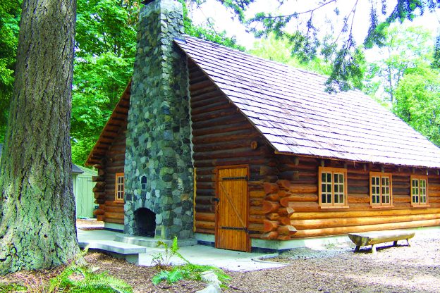
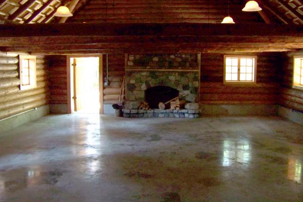
See the exterior, entrance, fireplace, and stage of the meeting lodge.
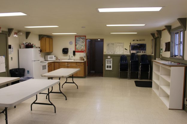
The classroom building has tables and a kitchen inside.
In Terramagne-America, the Dumplin Creek Reservation belongs to the Red Cherokee Tribe of Tennessee. It consists of two remnants, parcels of 198 acres and 122 acres, divided by Interstate 40. The 198 parcel off Exit 407 is more developed, while the 122 parcel is more rural. Compare with this acquisition in local-America.
Here you can see part of the Dumplin Creek Reservation 198 parcel before development. These are some of the roads.
For the development, see the statistics, gateway map, and collage.
An area sitemap shows the location of the development. This development sitemap shows a closeup of the Dumplin Creek Reservation. Among the standard mall stores are a tribal art gallery, a craft supply shop, a specialty store selling traditional foods, and a restaurant. The three outlots closest to the shopping center hold a casino, a hotel, and a cultural center that includes a Cherokee museum and souvenir shop. The next two outlots just across the access road hold apartment complexes, primarily intended for people who work at the shopping center so they can walk or bike to work. Just beyond those lie Dumplin Pond and Dumplin Creek; the large unmarked space there is a park which includes a variety of sacred spaces. To the lower right, across the winding road, lie six more outlots. These include some of the tribal facilities such as the school and community center (inside the closed rectangle) and the health clinic and small business park. The other four outlots are subdivisions with multiplex or single-family houses in a fairly modern style. Around the developed core of the parcel lies a wide band of grass and brush left wild. Underpasses for wildlife, treelines, and other nature zones help connect this area with the nearby Smoky Mountains National Park on one side and additional urban refuges on the other side.
In T-America, The Black Smoke Reservation belongs to the Black Cherokee Tribe of Tennessee.
This map shows the long view of the property outline for the Black Smoke Reservation. Sevierville is in the lower left corner of the map. Here's a closeup of the property outline. This section spans around 133 acres of mixed deciduous and evergreen forest. It's about 15 miles to Sevierville, 24 miles to Great Smoky Mountains National Park, 20 miles to Gatlinburg, and 39 miles to Knoxville.
This large section is the reservation proper, mostly wilderness. The light-colored section between the wilderness and the road is at the junction of several parcels. It holds some of the tribe's common buildings.
See the access road in autumn and winter with mountains. A winding road weaves through the mountains. In spring there is snow, but by summer it's all green.
This road leads to the Black Smoke Reservation clanhouse. Coming into the foyer, the lounge is to the left and the sitting room is to the right. The foyer is called the tree room. It includes a post office with small, medium, and large mailboxes. The lounge includes stone fireplaces with sidebar and oven, a kitchenette, a coffee table, easy chairs, and a couch. The kitchenette holds simple meals at regular times each day. Large windows overlook the grounds outside. This entrance leads to the sitting room.
This is a long view of the clanhouse lot sitemap, which is about 9 acres, adjacent to the reservation proper. See a medium view and a closeup view of the property outline.
Here is a long view of the property outline for the Bear's Head parcel, which is about 10 acres, adjacent to the reservation proper. See medium and closeup views of the property outline.
Mountain Ash Way has about 65 acres, adjacent to the reservation proper. In this long view of the property sitemap, Sevierville is visible in the center left and Pigeon Forge in the lower left. See medium and closeup views of the property outlines. Of the original 64 lots, 39 have been allotted to individuals or families, and the rest is held in common by the tribe. This gives the tribe some land which can be sold, mortgaged, or otherwise handled more typically but still falls within reservation lines for legal purposes. As usual, the tribe gets right of first refusal for any internal or adjacent property offered for sale. See sitemaps of lots 1-20 and 25-30, 10-25, 32-41, 47-64, and a different view of 10-25.
The Mountain Valley parcel is about 50 acres, adjacent to the reservation proper. See a long view, medium view, and closeup of the property outline.
White Oak Ridge has cabins of assorted sizes.
Sevier County is in Tennessee.
On this map, the Dumplin Creek Reservation has its developed 198-acre parcel in the southeast quadrant of the intersection between Interstate 40 and Highway 66. The Black Smoke Reservation (133 acres) is right about where it says District 7, above Sevierville.
See the exterior, entrance, fireplace, and stage of the meeting lodge.
The classroom building has tables and a kitchen inside.
In Terramagne-America, the Dumplin Creek Reservation belongs to the Red Cherokee Tribe of Tennessee. It consists of two remnants, parcels of 198 acres and 122 acres, divided by Interstate 40. The 198 parcel off Exit 407 is more developed, while the 122 parcel is more rural. Compare with this acquisition in local-America.
Here you can see part of the Dumplin Creek Reservation 198 parcel before development. These are some of the roads.
For the development, see the statistics, gateway map, and collage.
An area sitemap shows the location of the development. This development sitemap shows a closeup of the Dumplin Creek Reservation. Among the standard mall stores are a tribal art gallery, a craft supply shop, a specialty store selling traditional foods, and a restaurant. The three outlots closest to the shopping center hold a casino, a hotel, and a cultural center that includes a Cherokee museum and souvenir shop. The next two outlots just across the access road hold apartment complexes, primarily intended for people who work at the shopping center so they can walk or bike to work. Just beyond those lie Dumplin Pond and Dumplin Creek; the large unmarked space there is a park which includes a variety of sacred spaces. To the lower right, across the winding road, lie six more outlots. These include some of the tribal facilities such as the school and community center (inside the closed rectangle) and the health clinic and small business park. The other four outlots are subdivisions with multiplex or single-family houses in a fairly modern style. Around the developed core of the parcel lies a wide band of grass and brush left wild. Underpasses for wildlife, treelines, and other nature zones help connect this area with the nearby Smoky Mountains National Park on one side and additional urban refuges on the other side.
In T-America, The Black Smoke Reservation belongs to the Black Cherokee Tribe of Tennessee.
This map shows the long view of the property outline for the Black Smoke Reservation. Sevierville is in the lower left corner of the map. Here's a closeup of the property outline. This section spans around 133 acres of mixed deciduous and evergreen forest. It's about 15 miles to Sevierville, 24 miles to Great Smoky Mountains National Park, 20 miles to Gatlinburg, and 39 miles to Knoxville.
This large section is the reservation proper, mostly wilderness. The light-colored section between the wilderness and the road is at the junction of several parcels. It holds some of the tribe's common buildings.
See the access road in autumn and winter with mountains. A winding road weaves through the mountains. In spring there is snow, but by summer it's all green.
This road leads to the Black Smoke Reservation clanhouse. Coming into the foyer, the lounge is to the left and the sitting room is to the right. The foyer is called the tree room. It includes a post office with small, medium, and large mailboxes. The lounge includes stone fireplaces with sidebar and oven, a kitchenette, a coffee table, easy chairs, and a couch. The kitchenette holds simple meals at regular times each day. Large windows overlook the grounds outside. This entrance leads to the sitting room.
This is a long view of the clanhouse lot sitemap, which is about 9 acres, adjacent to the reservation proper. See a medium view and a closeup view of the property outline.
Here is a long view of the property outline for the Bear's Head parcel, which is about 10 acres, adjacent to the reservation proper. See medium and closeup views of the property outline.
Mountain Ash Way has about 65 acres, adjacent to the reservation proper. In this long view of the property sitemap, Sevierville is visible in the center left and Pigeon Forge in the lower left. See medium and closeup views of the property outlines. Of the original 64 lots, 39 have been allotted to individuals or families, and the rest is held in common by the tribe. This gives the tribe some land which can be sold, mortgaged, or otherwise handled more typically but still falls within reservation lines for legal purposes. As usual, the tribe gets right of first refusal for any internal or adjacent property offered for sale. See sitemaps of lots 1-20 and 25-30, 10-25, 32-41, 47-64, and a different view of 10-25.
The Mountain Valley parcel is about 50 acres, adjacent to the reservation proper. See a long view, medium view, and closeup of the property outline.
White Oak Ridge has cabins of assorted sizes.